Sunrise Over Amanohashidate

Sunrise Over Amanohashidate

Thursday, June 23, 2011

Day 50 (September 3): Omuta(大牟田市) to Nagasaki (長崎市)or "Was Emperor Showa (Hirohito) popular here?"

NB: For a complete map of this trip go to my map at http://maps.google.com/maps/ms?ie=UTF&msa=0&msid=212604391466540829641.00049962cafa13bd403f5


Day 50. Friday, September 3, 2010. Omuta to Nagasaki.

I had b'fast with Sato and his family, had a photo taken then set off for the ferry to Shimabara at Nagasu. Took only 40 minutes to cover the 12 kms but, as seems to be the case in Kyushu, the road was narrow and fairly heavily trafficked.

Sitting on deck now in port waiting for departure. The various peaks comprising volcanic Mt. Unzen are in the clouds. I remember the last eruption in 1995 which forced the evacuation of a number of towns.

11:45 pm, "Catholic Center" YH. Arrived here across from Urakami Cathedral at 3:30. Hot ride, but only had to walk the bicycle a few times. The only long tunnel was a Grade 1 down into the eastern section of Nagasaki called Hotaruchaya.
Visited A-Bomb museum. Once again, absolutely nothing about the Emperor, at least in English. I wonder if his "dithering" after Hiroshima made him an unpopular figure among survivors here.
Found Amy's hotel, ANA Glover Hill. Nice place. May have the "Lunch and Sweets Buffet" there tomorrow. Tonight ate "chyampon" across the street from that hotel. Sake and beer. Walked through Chinatown and then into "Nihontown" on way back to Nagasaki JR and the streetcar. Dejima and Glover Hill tomorrow.


January 25, 2011: Hotaruchaya means "tea house of the fireflies". It's the kind of local color that tells me I'll return to Nagasaki again some day.


June 8, 2011.
I well remember the feeling I had after I left the Chinese restaurant across from the ANA Glover Hill Hotel. The chyampon certainly was good and the sake and beer dissipated any clouds that might have formed. I was in a contented mood as I wandered into Chinatown and then investigated the Hotel Monterey, but something was lacking. I needed to talk to someone about what I was experiencing. Over a cup of coffee perhaps. I was full of words and emotion to the point of bursting yet there was no outlet.I was not feeling discontent, but a bit frustrated.

Day 51 (September 4): In Nagasaki (長崎市)or "Lying low in the heat of Nagasaki"


Day 51. Saturday, September 4, 2010. In Nagasaki.

Hot. Brilliant sunshine all day. A little cloud cover would have helped.
Started with b'fast at Nagasaki JR then took the streetcar to the Edo Period Dutch enclave called Dejima. It once was an island in the bay which effectively isolated the small foreign population from the natives. Some buildings reconstructed, some exhibits, but generally a shell. Next hung around the ANA Glover Hill Hotel waiting for the lunch buffet. Afterward walked up the hill to the Glover Gardens. A bit depressing as the lives of Glover and other foreigners in 19th c. Nagasaki remind me a bit of today. A special class because they were foreign and so sometimes given privileges and a lifestyle impossible in their home countries, but at the same time limited by an impenetrable cultural and physiological barrier.
The old "western" houses on Glover Hill are interesting and seem to be furnished with period furniture though it's condition is deteriorated. I wonder how people back then viewed it. How will our furnishings and dress be thought of 125 years from now?
Came back to the YH early to escape the heat and plan for tomorrow. The ferry from Mogi 11 kms south of here to Amakusa Island leaves at 7. The next is at 10. That means I have to push off no later than 5:30.

Day 52 (September 5): Nagasaki (長崎市)to Akune(阿久根市) or "Manuring Festival just missed"


Day 52. Sunday, September 5, 2010. Nagasaki to Akune, Kagoshima-ken.

Alarm at 4:50; up at 4:55; waiting in the YH lobby for the doors to be unlocked at 5:05. The distance to the ferry at Mogi for Amakusa-shima was 11 kms according to Google Maps. Their distances have been different. I knew there'd be a grade to climb to leave Nagasaki, but I didn't know it's steepness nor especially it's length. I hoped leaving before 5:30 would allow me enough time to get to Mogi for the first ferry at 7:00.
Desk man unlocked the doors at 5:20 and I was on the road a few moments later having loaded everything the night befoe. Still dark, but little traffic on the main thoroughfare passing Nagasaki Station. No traffic on Route 324 to Mogi. Climb it did, but not as long as I'd feared allowing me to reach the ferry in only 50 minutes, at 6:10.


Ferry reached Tomioka at 8:10. Followed Route 389 along the west coast of Amakusa. Fairly good riding. Saw a number of Catholic churches in the villages. They were in the center which I imagine is an important location. It also seemed by its ubiquitous odor that I had missed the yet-to-be-famous "Manuring Festival" by only a day.


Made Ushibuka by about 12:10, but had to wait for the ferry until 1:30. Upon landing on Nagashima the road went straight up, an ill omen. 17 kms of ups and downs climaxed at the highway bridge to the mainland. The pedestrian walkway was no wider than the handlebars and so forced me to go forward at an exceptionally slow and awkward pace.

I wanted to reach the junction with Route 3 at a minimum, but, on getting there, found nothing even hinting at accommodation so I turned right and proceeded south until the town of Akune.
It was nearly 5:00 and still no sign of any sort of hotels so I stopped to ask at a Hotto Motto, a nationwide bento chain. I was directed to the only hotel in town which was "Rocks-Inn". Much more comfortable than it's name, but a "business hotel" is a business hotel. Yakiniku and beer down the street rounded off the day.


June 10, 2011.
Riding across the island district of Amakusa was a treat. Traffic was non-existent or very light on the west coast. In contrast, once I was back on mainland Kyushu I needed to be very careful given the high volume of traffic. The rural beauty of Amakusa yielded to the practical but blighting presence of countless small businesses serving the populations of closely spaced towns along Rte. 3, the main road from Kumamoto to Kagoshima.

Day 53 (September 6): Akune(阿久根市) to Kagoshima (鹿児島市)or "Shadows of WW2: gun emplacements.")

Day 53. Monday, September 6, 2010. Akune to Kagoshima.

After a "western" b'fast at 7:30 I set off on what must be one of Japan's worst trunk roads, Route 3. Narrow. Verges made impassable to bicycles for the weeds. Narrow, gutter-covering, cracked-pavement sidepaths where they existed at all. Forced to contend with fairly heavy traffic including heavy trucks. There were a few bright spots, especially after Satsuma-sendai for a few kms, but generally awful most of the way into Kagoshima-shi.

Saw one interesting safety notice on the coast. It showed photos of dangerous locations which included old, WW2 era coastal gun emplacements. Got me to thinking for the next hour what it would have been like to face those guns in a landing craft in the autumn of 1945, the date for the planned American invasion of Kyushu. No one wants to go on record as saying the atomic bombings were a good thing, but... Would the Imperial Army suddenly have thrown down their weapons after the ferocious defense of Okinawa?
Finally arrived at Kagoshima-chuo Station at 5:00. Tourist Information told me that the ferry I wanted to take at Ibusuki to Minami-osumi on the east coast of the bay was no longer running. For a bicyclist THAT is important information! Plenty of business hotels near the station. Checked in at a Toyoko-Inn then changed the tube that I'd pumped up three times already that day. Shower. Italian dinner at the station mall. And, for the first time on the trip, I watched a movie: "Sherlock Holmes". Man does not live by pedaling a bicycle alone.
Rumors on the TV news about a typhoon near Nagasaki heading NE. Lucky for me.


A more detailed time line:

7:30 a.m.: left Rocks Inn hotel in Akune
9:42 a.m.: stopped at Sunkus shop on Rte. 3 about 16 km so. of Akune, 1.3 km south of Satsumataki Station
10:26 a.m.: stopped at Lawson shop on Rte. 3 in Satsumasendai Koguramachi, 2.8 km east of Kusamichi Station
11:49 a.m.: stopped at Gusto restaurant in Satsumasendai on Rte. 3 about 25 km so. of Akune, near Kamisendai Station
1:06 p.m.: stopped at A-Coop shop on Rte. 3 near Kushikino Station in Ichikikushikino
1:19 p.m.: photo of public housing on Rte. 3 in Ichikikushikino
2:10 p.m.: stopped at Family Mart shop on Rte. 3 in Higashi-Ichikicho about 8 km east of Ichikikushikino, near Yunomoto Station
3:30 p.m.: stopped at Lawson shop near Ijuinkita PO 20 km east of Ichikikushikino
5:00 p.m.: arrived at Kagoshima Chuo Station

Day 54 (September 7): In Kagoshima (鹿児島市)or "To ship or not to ship?"


Day 54. Tuesday, September 7, 2010. In Kagoshima.

Decided to stay on the west side of the bay this day. Rode out to the ferry port to time the trip and orient myself. Rain on and off most of the day, mostly a drizzle but occasionally a downpour for a few minutes. Checked in for a second night at the hotel. I sorted through my things early in the morning: those to keep, those to send back to Tokyo and those to chuck as gomi ("trash"). Walked over to a nearby Kuroneko Yamato office and sent three bags back to Tokyo for only ¥2,500. Among the gomitized items was the one-man tent I bought from Jackie Kountz back in 1990 or so. I discovered that the floor wasn't waterproof and the frame wasn't self-supporting. Should have sent stuff back sooner but, weeks ago, that might have seemed like a partial "surrender". I didn't hesitate today.
I've given up the idea of catching a ferry back to Tokyo especially as the next direct one to Tokyo from Shibushi leaves on the 13th. The only question now is whether to bag my bicycle and take it on the train or take it to the delivery service, too. The former will mean lugging it from train to train and then reassembling it at Ikebukuro; the latter is just a matter of money.
So much is just "a matter of money".


June 12, 2011.
By this time I was getting a bit travel weary. Perhaps this was due to my nearing the end of the trip with the accompanying letdown of "achieving" my goal. While riding I often considered that there is a great difference between "doing" something and "having done" it. Reminiscence - no matter the relative comfort of the place where it is done - just does not compare to action with the sun and wind on my face and daily discovery of the unknown.

A word about preparation for such a trip: if you decide to bring a tent, make sure it is self-supporting, i.e. doesn't have to be secured by pegs or lines. There were many places - including the approach to the Karakachi Pass between Obihiro and Furano - where it wasn't possible to set up the tent though the ground was relatively flat. And make sure the floor is waterproof.

Ferries: it was difficult if not impossible to get information on more local ferries. I often had to just show up at a port and hope for the best. Also note that some smaller ferry lines have been discontinued yet appear on paper maps and Google Maps. In particular, the ferry from Shibushi to Tokyo (the route is Okinawa-Shibushi-Tokyo) sometimes does not operate but, when it does, is rather infrequent at 3-4 times a month.

Day 55 (September 8): Kagoshima(鹿児島市) to Cape Sata(佐多岬)to Minami-osumi (南大隅町)or "Fin de cycle"


Day 55. Wednesday, September 8, 2010. Kagoshima to Cape Sata.

(written at 4:45, September 9)
I thought it best to have something in my stomach before leaving Kagoshima so ate toast at the hotel. Made it to the port and boarded first as bicyclists are allowed to do. A crewman having secured my bike with rope and chocks, I went up to the passenger deck and, as I had learned to do on other ferries, sought out a seat near an outlet.
Landed at Tarumizu at 9:40 and set off at high speed along a reasonably flat road in places lined by palms. The picnic ended at Kanoya about 10 kms on with a few moderate hills. I was surprised, however, that I could take them without excessive effort.


I reached Minami-osumi, which I had originally planned to be my stopping place for the day, at 12:00. I estimated that I might be able to cover the remaining 35 kms to Cape Sata in 2.5 hours though the squiggly road ahead on the map indicated a grade. By this time I had decided to spend at least the last hours of my 60th birthday on the 9th with Akemi and Amy at home in Tokyo so I was determined to push on. I even entertained the idea of speeding back to Tarumizu and catching the ferry back to Kagoshima. The gods were listening, of course.
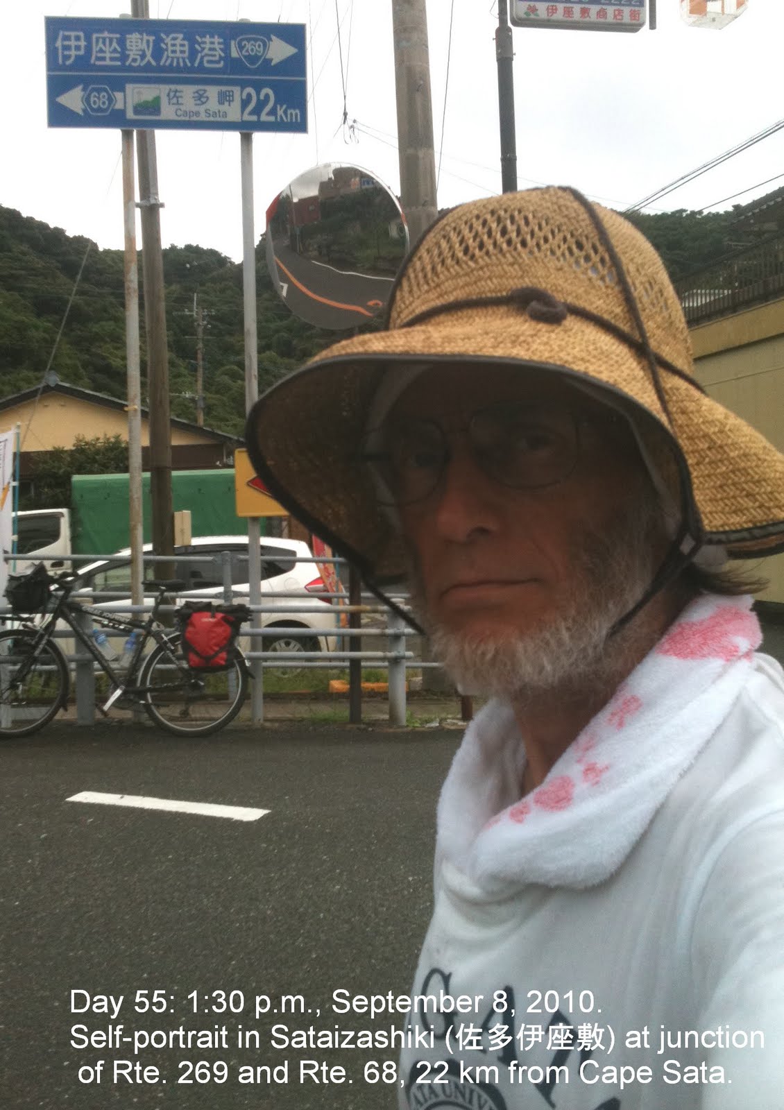
Progress was good so I took a pineapple and coffeemilk break at Daiichisata (NB: Rather, Sataizushiki). Just ahead I spotted a sign indicating that Cape Sata was just 22 kms further. At that point the road rose consistently upwards. Of course. How was I to know that an offering of pineapple and coffeemilk was expected?
I rode. I pushed. I looked up and caught glimpses of road I hoped I wouldn't actually see. I did, but "what goes up..." (even in Japan). I soon reached the turnoff for Cape Sata. The road I turned onto was once a toll road as evidenced by an abandoned booth. Forward and soon upward I went dodging fallen palm fronds. Up and down, around curves catching sight of the coastline below. Finally sensing I must be near, I prepared myself to see... a tollbooth! No, I thought, not the legendary tollbooth that once denied access to the cape by bicyclists! It was supposed to have been closed several years ago. I approached behind a family-filled van and heard the words "go-hyaku en". Argh! What could I do but... pay the ¥500 so sweetly requested. Newly encouraged I launched myself upwards.
Finally, with a fine view of the coast far below, I rolled into a parking area. There, dead ahead, was a narrow tunnel and what I took for a toll collector. Could I not ride or at least walk my bicycle the rest of the way to the cape? Resignedly, I bought a Coke - only the second one of the trip - sat down and considered what to do.
Facing the reality of the situation I took out the ¥150 I saw written on the sign at the tunnel entrance and advanced. Not needed! Passed through without payment, but without bicycle. Exiting the tunnel I saw the reason for the prohibition as the concrete path descended steeply wide enough for just two abreast. Up and down. Arrive at small shrine. Skip that one this time. Up towards the lighthouse/observation platform. Great views of the immediate coast and also two islands to the south, one with a prominent mountain. Past an abandoned two-story rest house, up 20 roughly lain stone steps and there I was. A small clearing and the sign that made the end of my journey "official" (never mind having to get back to Kagoshima and Tokyo!).
A lovely view. Open ocean stretching who knows how far.

Stayed a while then returned to the bike and started back at 4:00. Now it was a race to get back at least as far as Minami-osumi where there was a hostel. Ride. Push. More pushing than riding it seemed, but when I made a short tunnel I knew it was literally downhill most of the way to Daiichisata and more pineapple. No fixation with that fruit in case you're wondering. Juicy. Nothing like it on a day when you can wring sweat from your shirt.
Onward. Catching views of Mt. Kaimon on the opposite shore, a magnificent volcano now clear of clouds and about to be silhouetted by a sun quickly sinking in the western sky. Stopped several time to photograph it despite the growing threat of being benighted on the road.

I was forgiven as I arrived back in Minami-osumi at 6:30 and then rewarded by being directed by the gods to an onsen hotel within walking distance of the YH. A room so huge it might have held 3 or 4 of the business hotel rooms I have stayed in. Only the "love hotel" outside Hiroshima way back when was comparable, at least in size. For dinner in the hotel restaurant "chyampon udon" and a Kirin draft. I doubt I'll enjoy that Kyushu dish soon.
Bathed and fed I faced only the two-hour ride back to the ferry at Tarumizu. There will be plenty of time for reflection.


A more detailed time line:

8:29 a.m.: stopped at Lawson shop near ferry port in Kagoshima
9:40 a.m.: ferry arrives in Tarumizu
10:23 a.m.: photo at Arahira Shrine on Rte. 68, 15 km so. of Tarumizu
11:17 a.m.: stopped at Lawson in Nishikimachi Shinkawa 3.5 km no. of Kinko
11:53 a.m.: stopped at Lawson in Minami-ohsumi on Rte 269, 37 km so. of Tarumizu
1:09 p.m.: stopped at A-Coop shop in Sataizushiki near junction of Rte. 269 & 68
1:30 p.m.: photo leaving Sataizushiki, 22 km from Cape Sata
3:05 p.m.: arrived at Cape Sata parking lot and pedestrian tunnel
3:29 p.m.: photo on arrival at Cape Sata marker
5:17 p.m.: stopped at A-Coop shop in Sataizushiki again
6:02 p.m.: photo of Mt. Kaimon from Rte. 269, 6 km so. of Minami-ohsumi
6:30 p.m.: arrival at Nejime Onsen Neppi Hotel in Minami-ohsumi


September 9, 2010: A confession: I'm on the Shinkansen just about to arrive at Nagoya listening to a catchy little tune I have often hummed while riding hard and especially pushing the loaded bicycle up steep grades in pouring rain. "Die Fahne Hoch" a.k.a. the "Horst Wessel Song". Hitler made it the Nazi Party anthem rivaling "Deutschland Uber Alles".It only proves that things are often put to uses never imagined by the creator. Rollover, Adolf.

Day 56 (September 9): Minami-osumi(南大隅町) to Tokyo (東京) or "Home again, home again..."


Day 56. Thursday, September 9, 2010. My 60th birthday. Kagoshima to Tokyo.

BTW, I have no idea what the lyrics of "Die Fahne Hoch" mean.

Left the Hotel Nepi early. Loading the bike was a snap. The staff insisted that I leave it in the lobby last night. A bright morning. More pushing than yesterday, but, to my surprise it took exactly two hours, arriving at Tarumizu at 8:20 for the 8:25 ferry. Stopped at Gusto on the Kagoshima side for b'fast. Arrived at Kuroneko Yamato and gave them the undisassembled bicycle to ship back home (NB: Disassembling it would have not changed the shipping charge.). Souvenir buying at the station mall and then a stop at Daiei for food and drink for the 8-hour train ride back to Tokyo. Left Kagoshima on the 11:52 "Tsubame" Shinkansen.

Glad I did this trip, but glad it's over too. Miss my wife, kids, friends and "normal" life. It takes will power to keep going day after day, but it's not the physical aspect that often suggests quitting and must be overcome, but the psychological ones. This latter includes a feeling of isolation that arises unexpectedly from time to time and threatens an abrupt end to the undertaking. In addition, there is that doubt about the very value of attempting such a venture. Perhaps it's real value has yet to reveal itself. Perhaps changes have occurred of which I am not yet aware.
"All will be revealed."


A more detailed time line:

7:24 a.m.: photo at Arahira Shrine (high tide) on Rte. 68 about 15 km so. of Tarumizu
7:48 a.m.: stopped at Lawson in Shinjo, Tarumizu about 8.8 km so. of ferry port
8:26 a.m.: arrived at Tarumizu ferry port
8:30 a.m.: departure of ferry for Kagoshima
11:55 a.m.: departure by Shinkansen from Kagoshima Chuo Station
8:45 p.m.: arrived at home in Minami Tokiwadai, Itabashi-ku, Tokyo


NB: For a complete map of this trip go to my map at http://maps.google.com/maps/ms?ie=UTF&msa=0&msid=212604391466540829641.00049962cafa13bd403f5